


Droneradar
Description of Droneradar
Droneradar is an official application designed to assist drone operators in navigating the complex landscape of aviation regulations. This app is particularly beneficial for those flying unmanned aerial vehicles (UAVs), commonly referred to as drones, and is available for the Android platform, allowing users to download Droneradar with ease.
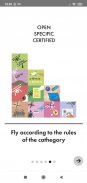
The application is fully integrated with PansaUTM, which is administered by the Polish Air Navigation Services Agency. Moreover, it has the backing of the Polish Civil Aviation Office (ULC), ensuring that users have access to reliable information regarding drone operations. Droneradar meets the requirements established by the EC Delegated Regulation 2019/945 and Implementing Regulation 2019/947, which adds to its credibility and reliability.
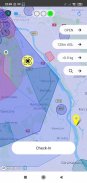
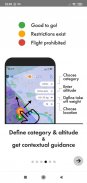
Upon launching Droneradar, users are encouraged to enable location services for optimal performance. The interface features a color-coded system to inform users about the status of their flying environment. A green indicator signals that flying is permitted, albeit with caution regarding altitude. Yellow indicates that restrictions may apply, and users can obtain detailed information by accessing the signaller icon. A red indicator prohibits flying altogether, ensuring safety in restricted airspace.
Droneradar also facilitates a Check-In feature, allowing drone operators to register their flight location. This involves entering contact information and providing details about the type of drone in use. While this information is voluntary, it helps in enhancing safety by marking the user's flying area on the Droneradar map. This transparency among users contributes to a more organized airspace environment.
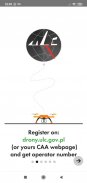
For those operating drones weighing over 250 grams or equipped with cameras, registration is required at drony.ulc.gov.pl. The Drone Operator Registration number must be entered in the Droneradar application during flight Check-In to comply with regulations. This requirement emphasizes the importance of adhering to legal standards while flying drones.
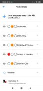
Droneradar promotes safe flying practices by emphasizing the need for users to remain aware of their surroundings. The app encourages operators to always keep their drone in sight and to avoid flying near airports. The application provides visual cues to indicate proximity to airports, thereby helping users make informed decisions about where and when to fly.
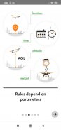
The app also advises users to maintain a maximum altitude of 120 meters (approximately 450 feet) in the Open category of drone operations. This altitude restriction is in place to ensure that unmanned aerial vehicles do not interfere with manned aircraft, which generally operate at a minimum altitude of 150 meters AGL (Above Ground Level). By adhering to these guidelines, drone operators can effectively minimize risks associated with potential drone failures.
Droneradar serves as a valuable tool for both novice and experienced drone operators. It provides crucial information about surrounding airspace and other users, allowing for a more informed flying experience. The application is designed with user safety in mind, making it a helpful companion for those venturing into the world of drone flying.
Additionally, the app’s user-friendly interface allows operators to quickly assess their flying environment. By simply observing the color of the lights at the top of the screen, users can easily determine whether they can proceed with their flight. This straightforward approach simplifies the process of checking airspace regulations, making it accessible for a wide range of users.
The integration with PansaUTM adds another layer of functionality, enabling users to log in and follow specific instructions if a flight plan is required for their intended location. This feature ensures that drone operators remain compliant with regulations while planning their flights.
As drone flying continues to gain popularity, tools like Droneradar play a critical role in promoting safe and responsible operations. The application not only assists in understanding regulations but also fosters a culture of safety among drone users. By leveraging the information and features provided, operators can enjoy a more secure flying experience.
For more information about Droneradar and its functionalities, users can explore the official website, droneradar.eu, which offers additional resources and guidance for drone operators.
Droneradar stands out as an essential application for anyone involved in drone operations. Its commitment to safety, regulatory compliance, and user-friendly design makes it a valuable resource within the aviation community, ensuring that both beginner and seasoned drone pilots can navigate the skies responsibly.
Droneradar - Version 2.0.899
(02-02-2021)Droneradar - APK Information
APK Version: 2.0.899Package: eu.droneradar.droneradarLatest Version of Droneradar
Other versions


Apps in the same category

You may also like...


